ENGAGE IMS/CAD redefines how public safety organizations respond to critical events. With real-time coordination, intelligent dispatching, and mobile-enabled teams, it empowers first responders to act faster, safer, and smarter— from the control room to the field.
ENGAGE IMS/CAD is a next-generation integrated emergency response platform tailored for public safety organizations, enabling real-time coordination between command centers and field units. With robust features such as computer-aided dispatch (CAD), intelligent resource allocation, and situational awareness tools, ENGAGE transforms how agencies manage incidents and respond to emergencies.
This powerful suite supports call-taking, dispatching, field communication, analytics, and cross-agency collaboration—all within a secure, scalable architecture. Its modular design allows flexible deployment and customization, empowering agencies to enhance operational efficiency, reduce response times, and deliver smarter public safety outcomes.
Available as a high-performance desktop client or a fully featured web-based Human Machine Interface (HMI)
ENGAGE Desktop is the high performance thick client of the ENGAGE IMS/CAD suite aiming at operational efficiency by seamlessly integrating call handling, dispatching, 3D mapping, field communications, and data reporting.
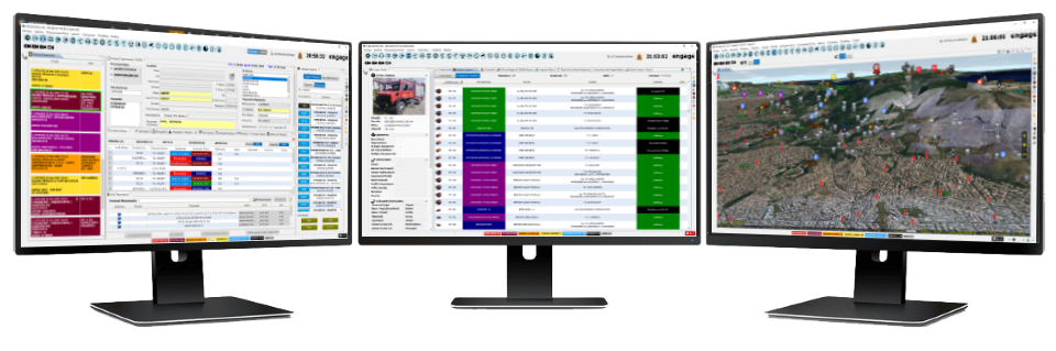
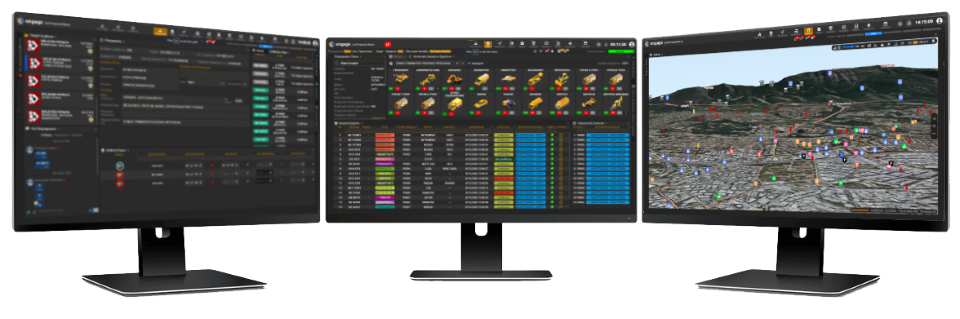
Seamlessly accessible via standard web browsers, ENGAGE Web offers the same comprehensive features as its Desktop counterpart. From call handling to 3D mapping, field communications, and data reporting, ENGAGE Web ensures efficient operations anytime, anywhere.

Seamless integration with ENGAGE 112 enables advanced multi-channel communication—supporting audio, video, real-time text (RTT), MMS, and SMS—between citizens in distress and emergency services. The platform empowers call takers with a unified interface to receive and manage diverse media inputs and share contextual data with dispatchers.

Centralizes and streamlines the lifecycle of all types of incidents—emergency or planned—by enabling multi-agency logging, classification, escalation, prioritization, and interoperability. Supports both tactical and strategic decision-making with enhanced collaboration and structured response workflows for complex operations.

Provides comprehensive tools for managing resources across agencies and services. Enables dynamic allocation and monitoring of units, vehicles, and personnel based on availability, capability, and location for optimal operational readiness.

Automates personnel scheduling and shift planning based on skills, roles, and operational demands. Facilitates resource forecasting and ensures consistent staffing for uninterrupted coverage during routine operations or major events.

ENGAGE IMS/CAD fosters real-time collaboration between dispatchers, field units, civil protection agencies, and command personnel through a secure, integrated communication environment. It supports dynamic information sharing—such as incident updates, multimedia attachments, map annotations, and situational alerts—across multiple stakeholders and jurisdictions.

Integrates voice communications over IP-based networks, allowing dispatchers to connect and control multiple radio channels through a unified interface. Supports interoperability between legacy analog and modern digital radio systems, enabling seamless communication with field units across agencies and jurisdictions.

Delivers real-time geolocation and status updates for all deployed resources, including emergency vehicles, personnel, drones, and equipment. Integrates with GPS and Automatic Vehicle Location (AVL) systems to visualize movement on dynamic maps, monitor route efficiency, and set geofencing alerts. Enhances situational awareness, improves response times, and ensures optimal resource utilization during critical operations.

Effectively manages airborne assets—including helicopters, UAVs, and fixed-wing aircraft—through a comprehensive suite of tools for flight planning, mission dispatch, live tracking, and real-time coordination with ground forces. Supports airspace deconfliction, payload tasking, and post-mission reporting, making it ideal for search and rescue, wildfire surveillance, border monitoring, and response in hard-to-reach or large-scale incident zones.

Integrates advanced decision support tools such as Forest Fire and Flood Simulators as well as the GSense (Post earthquake building damage assessment) system to aid situational assessment and response planning. These models help predict fire spread, flood extent and earthquake expected damages based on real-time data, enhancing preparedness and supporting evidence-based decision-making during emergencies.

The integrated GIS engine delivers real-time spatial intelligence through high-resolution 2D and 3D map visualization, supporting dynamic overlays of incidents, units, assets, and infrastructure. Operators can edit, manage, and annotate vector layers directly within the platform, enabling the creation of custom map features, operational zones, and geofences. Seamless integration with external GIS sources and live data feeds ensures accurate geospatial awareness for tactical planning and mission execution.

Enables mobile teams to access mission-critical information, update statuses, and receive assignments through secure mobile apps or in-vehicle terminals. Supports seamless two-way communication between field units and command centers.

Combines a powerful desktop application with a lightweight web client to support both control room operators and mobile command users. Delivers a unified interface for monitoring, dispatching, and incident coordination from any location.
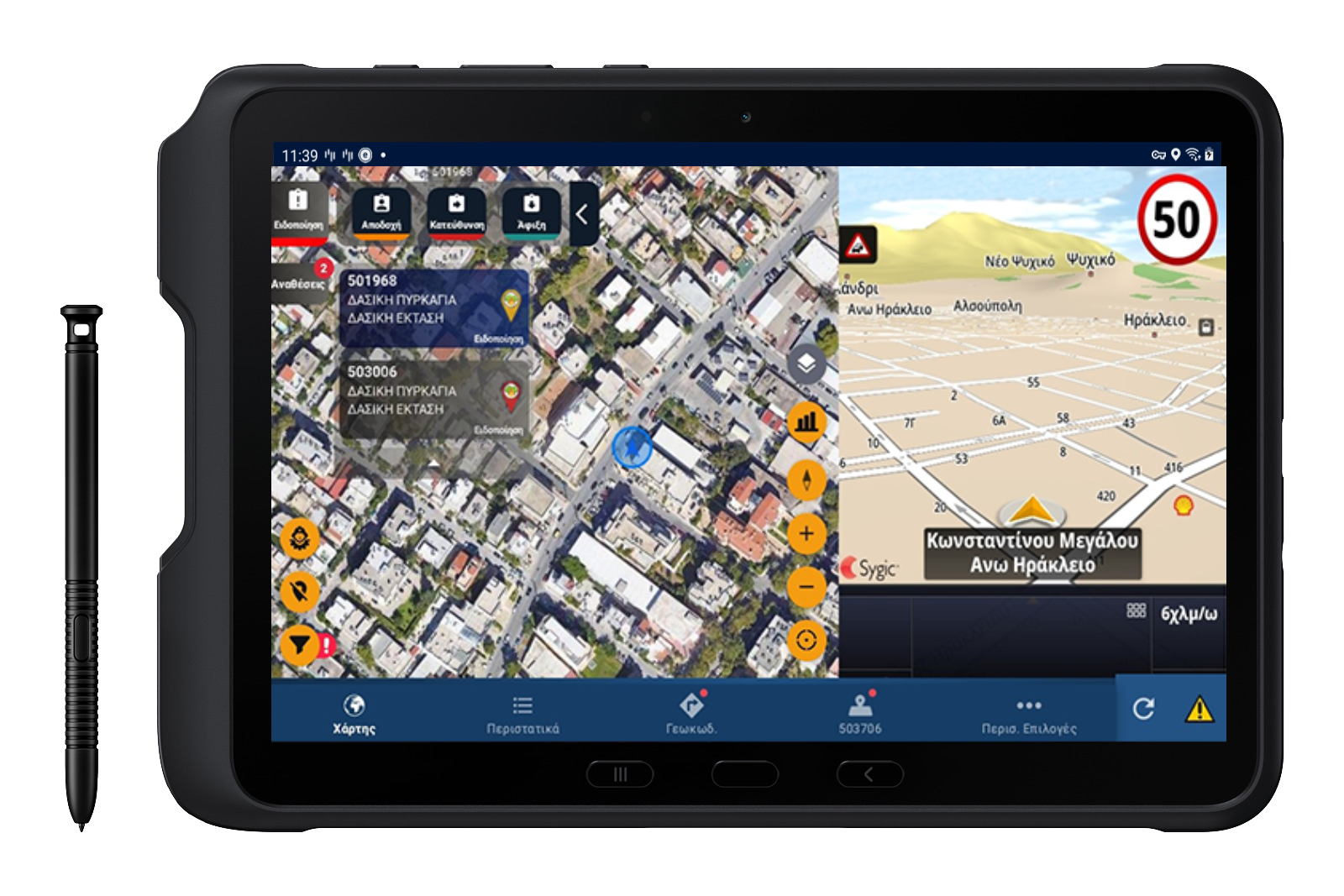
Offering a wide range of mobile data terminal applications to cover every need
ENGAGE Driver is an Android-based mobile application explicitly designed for Law enforcement, Fire and Emergency medical organizations vehicles for superior data on the move. Its purpose it to enable fast and accurate navigation to the emergency site and continious communication with the Dispatch Center.
ENGAGE Pilot is a cutting-edge aerial mission application designed for Public Safety aircraft pilots, delivering real-time situational awareness, seamless cross-unit communication, and optimized mission execution. With faster response times, dynamic flight path updates, and secure mission coordination, ENGAGE Pilot is the ultimate aerial response solution for public safety operations.
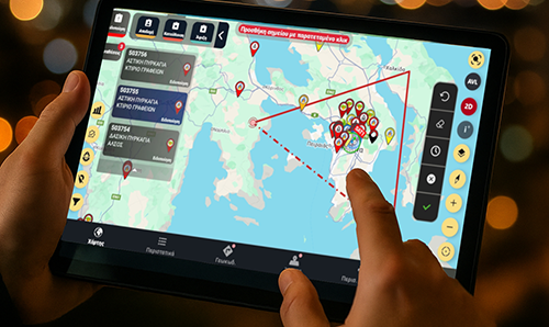
ENGAGE Commander is a tablet application that enables field incident commanders to access and exchange information with the operations room enhancing real-time responsiveness, bidirectional information flow and incident management from the emergency site.

ENGAGE Mobile is a superior Android app for field personnel. Access incident info, dispatch alerts, and emergency overviews instantly. Exchange data and video with the control center for swift response coordination. Stay connected and informed with ENGAGE Mobile – essential for frontline responders.
ENGAGE TRIAGE is a tablet application that enables field incident medical commanders to access and exchange information with the operations room enhancing real-time responsiveness, bidirectional information flow and incident management from the emergency site.

Real-time mission updates and optimized dispatching reduce delays, ensuring rapid deployment of emergency services.
Live tracking and integrated operational views improve decision-making and incident handling across all roles.
Unified command and communication among air, ground, and marine units improves mission collaboration and effectiveness.
Advanced planning and dispatch algorithms ensure efficient use of resources and personnel in real-time
Field units access live incident data, send multimedia, and collaborate seamlessly using smartphones and tablets.
Built with high-security standards to ensure data integrity, system reliability, and compliance with public safety requirements.
Get in touch with our team for detailed specifications, demo requests, or any other inquiries you may have.
CONTACT US